Legendary Snowman Trek
Overview
Regarded as one of the hardest and most spectacular treks in the world. Traverse the remote Lunana region, cross 11 passes over 4,500m, and witness untouched Himalayan beauty. Enjoy local cuisine, cultural immersion, and breathtaking scenery throughout the day.
This itinerary is designed to give you a comprehensive experience of Bhutan's unique culture and stunning landscapes.
Highlights
- Remote Lunana region
- Table Mountain (Zongophu Gang)
- Views of Jomolhari and Jichu Drake
- Highest settlements in Bhutan
What's Included
- Expert trekking guide & specialized cook
- Additional pack animals & yaks
- Satellite phone support
- All camping & permit fees
Places Visited
Itinerary
Day 1: Arrival in Paro & Pre-Trek Briefing
Touch down at Paro International Airport, navigating one of the world's most dramatic landing approaches as the aircraft weaves between Himalayan ridges before settling into the emerald valley below. Your lead guide and full support crew—cook, assistant guides, and horsemen who will manage your pack animals—are waiting at the arrival gate with a warm welcome. Transfer to your hotel in Paro town for a much-needed rest before the monumental journey ahead. The afternoon is dedicated to a comprehensive pre-trek briefing: your guide will walk you through every pass, campsite, and potential hazard of the 24-day route ahead. This is the time to finalize your gear, return any unnecessary items for storage, weigh your personal kit, and confirm that your camping equipment, sleeping bag, and high-altitude clothing are all in order. A porridge of information is shared—altitude sickness symptoms, permit protocols, wildlife encounters, and emergency evacuation procedures including the satellite phone. In the evening, enjoy a welcome dinner featuring traditional Bhutanese cuisine. Sleep well: tomorrow is your training day, and the mountains are watching.
Day 2: Acclimatization Hike: Tiger's Nest Monastery
Rise before sunrise and set out on what may be the most spiritually charged acclimatization hike on earth: the ascent to Taktsang Goemba, the legendary Tiger's Nest Monastery, perched 900 meters above the valley floor at an altitude of 3,120 meters. For the Snowman Trek, this day is far more than a warm-up—it is a physical assessment of your fitness, a calibration of your lungs, and an act of spiritual preparation. Walk steadily and deliberately through pine forests draped in silver moss, pausing to observe the increasing altitude's effect on your body. At the cafeteria viewpoint, rest and photograph the impossibly dramatic monastery clinging to the granite cliff across the gorge. Those who continue to the monastery itself will find sacred caves where Guru Rinpoche is said to have meditated for three months in the 8th century. Offer prayers and place a butter lamp—many trekkers seek his blessing for a safe passage through the mountains that lie ahead. The descent back to the valley takes another two hours, arriving in time for a hearty lunch. Spend the afternoon packing and repacking your daypack, ensuring weight distribution is optimal. Early dinner and sleep. Tomorrow the real journey begins.
Day 3: Paro to Shana: The Trek Begins
After an early breakfast, drive approximately 17 kilometers north up the Paro valley to Drukyel Dzong, the ruined fortress built in 1649 to celebrate victory over Tibetan invaders. On clear mornings, the sacred pyramid of Mt. Jomolhari (7,326m) towers magnificently at the end of the valley, a vision that will accompany you for the next several days. This is where the Snowman Trek officially begins. The initial trail is gentle and pastoral, following the Pa Chhu (Paro River) upstream through farmland, apple orchards, and scattered traditional farmhouses. As the valley narrows, the landscape transitions into dense forests of oak, pine, and rhododendron. You will cross several wooden footbridges adorned with fluttering prayer flags, each span offering a different view of the rushing, turquoise river below. Pass through army checkpoints near the Tibetan border—your guide will handle all permitting. Wildlife is plentiful here: Himalayan langurs swing through the canopy, and the riverbanks are alive with dippers and redstarts. After approximately 17–18 kilometers and 5–6 hours of trekking, arrive at Shana camp (2,850m), where your support crew has already pitched the tents and prepared hot soup. The sound of the river will carry you to sleep beneath a sky thick with stars.
Day 4: Shana to Thangthangkha: Into the National Park
Today is a longer, more demanding day as the trail pushes deeper into the pristine wilderness of Jigme Dorji National Park, Bhutan's largest protected area. The path continues along the Pa Chhu, gradually gaining elevation as the valley narrows and the character of the forest shifts from mixed broadleaf to dense rhododendron and towering fir. Cross several side streams on rustic log bridges, and navigate sections of trail that wind through rocky terrain above the river gorge. The further you walk from Shana, the more profoundly the silence of the mountains settles over you. Birdlife is remarkable in this corridor: watch for Himalayan monals displaying their iridescent plumage on rocky outcrops, and listen for the piercing call of the blood pheasant. The trail demands a steady pace; resist the temptation to rush. By mid-afternoon, the forest begins to thin and alpine meadows appear. Arrive at Thangthangkha camp (3,610m) after approximately 22 kilometers of trekking. The temperature drops sharply at this altitude, so layer up quickly upon arrival. If the sky is clear, Mt. Jomolhari now dominates the horizon to the north—closer, larger, and more imposing than it appeared from the valley. Hot tea and a warm meal wait at camp. Rest well: tomorrow brings your first real mountain views.
Day 5: Thangthangkha to Jangothang: Beneath Jomolhari
This is the day the Snowman Trek reveals its true nature, and many trekkers consider it the most visually spectacular section of the entire journey. The trail climbs steadily above the tree line, opening into a vast, U-shaped glacial valley. The landscape becomes purely alpine—short grasses, scattered boulders, and the occasional hardy wildflower clinging to the rocky soil. And then, as you round a final ridge, the view explodes: Mt. Jomolhari (7,326m), one of the most sacred mountains in the Bhutanese Buddhist world, fills the northern sky with its colossal south face. To the east, Jichu Drake (6,989m) rises like a companion sentinel. The scale of these mountains is humbling in a way that photographs cannot fully convey—they do not merely dominate the horizon; they redefine it. After approximately 19 kilometers and 4–5 hours of walking, arrive at Jangothang Base Camp (4,080m), widely described as one of the most beautiful campsites on earth. Ancient fortress ruins stand at the edge of camp, and yak herders' stone huts dot the valley. In the afternoon, take a short walk to acclimatize. Blue sheep (bharal) are often spotted grazing on the surrounding slopes. Watch the sunset paint Jomolhari in shades of amber and rose. This evening will stay with you for the rest of your life.
Day 6: Rest & Acclimatization at Jangothang
This dedicated acclimatization day at Jangothang (4,080m) is not optional—it is essential. The days ahead involve multiple passes above 4,500 meters and one crossing above 5,000 meters. Your body must adapt. The guide will assess each team member's condition individually, monitoring for signs of altitude sickness: headaches, nausea, fatigue, or disorientation. While resting, you have several excellent options to occupy the day while gently climbing higher to sleep lower. The most popular excursion is a hike to the twin Tshophu Lakes, two brilliant glacial pools at approximately 4,400 meters nestled beneath Jichu Drake. The trail climbs steadily through boulder fields and past yak trails, rewarding you with close-up views of the mountain's ice cliffs and a view of the Jomolhari massif from a higher vantage. Alternatively, follow yak trails toward the base of Jomolhari itself, reaching the edge of the glacier on a challenging scramble. Keep your eyes on the slopes: blue sheep are commonly seen here, and golden eagles circle overhead. Return to camp by mid-afternoon to rest, hydrate aggressively, and eat well. Your cook will prepare a hearty meal. Tomorrow the real Snowman challenge begins with the first high pass crossing.
Day 7: Jangothang to Lingshi: The First High Pass
Rise early for the most challenging day so far: crossing Nyeli La pass at 4,870 meters. After a hot breakfast, the trail begins climbing immediately from camp, switchbacking up rocky slopes with increasingly dramatic views of Jomolhari and Jichu Drake behind you. The altitude is felt with every step as the air grows noticeably thinner—maintain a slow, measured pace, and do not let the excitement of the views push you faster than your lungs can manage. Prayer flags at the summit of Nyeli La mark the crossing point, and the panoramic view from the top—Himalayan peaks stretching in every direction—is staggering. Add a stone to the cairn, a tradition of gratitude for safe passage. Descend steeply into the Lingshi valley, a completely different landscape from the Jomolhari world you've left behind. The wide basin opens into alpine meadows and yak pastures, and in the middle distance, the hilltop silhouette of Lingshi Dzong emerges—a remote 17th-century fortress that once guarded the route against Tibetan incursion. Arrive at Lingshi camp (4,010m) in the late afternoon. The sense of achievement is palpable around the campfire tonight. You have crossed your first great pass. Twenty-four days remain.
Day 8: Lingshi to Chebisa: Villages in the Mountains
After the demands of the previous day, today offers a gentler, more cultural walk—a welcome change of pace before the route becomes more remote and challenging. Leave Lingshi camp and pass through the village itself, where a small community of farmers and yak herders maintains a life of extraordinary self-sufficiency at over 4,000 meters. Your guide can arrange a brief visit to the dzong if the caretaker is present, offering a rare opportunity to see the interior of one of Bhutan's most isolated fortresses. From Lingshi, the trail descends gradually through mixed terrain of rocky pasture and scattered pine, crossing streams on stepping stones and log bridges. The walking is pleasant and allows you to appreciate the sweeping mountain landscape at a slower pace. After approximately 15 kilometers, arrive at Chebisa village (3,880m), a remarkably charming settlement of perhaps a dozen stone houses sheltered beneath a dramatic ridge. At the far end of the village, a waterfall cascades down the cliff face in a long white ribbon—in winter it freezes solid, but in September and October the spray fills the air with mist. Camp is set up near the waterfall. The sound of falling water, the smell of juniper smoke from the village hearths, and the completeness of the mountain silence make Chebisa one of the most atmospheric camps on the entire trek.
Day 9: Chebisa to Shomuthang: Blue Sheep Country
Depart Chebisa with a steep climb out of the valley, ascending swiftly to the Gombu La pass at 4,440 meters. The initial ascent is punishing but rewards with progressively expanding views over the valley you've left behind and across to the ranges that lie ahead. The pass area is habitat for one of the trek's most coveted wildlife sightings: the blue sheep, or bharal—stocky, nimble animals with grey-blue coats that graze on rocky slopes with extraordinary confidence. With luck and binoculars, you may spot them grazing in loose herds on the cliffsides near the pass. The descent from Gombu La drops through thick rhododendron forest—a tunnel of twisted branches and, in spring, blazing red blooms—before opening into the wide meadowland of the Shomuthang valley. This valley has a wild, untamed character; the landscape feels truly untouched, the silence broken only by the wind, distant streams, and occasional birdcall. Camp at Shomuthang (4,220m). The temperature drops sharply after sunset at this altitude. Layer up early, gather around the camp cook's fire for dinner, and share stories with your crew about the wildlife sightings of the day. The night sky here, far from any artificial light source, displays the Milky Way with startling clarity.
Day 10: Shomuthang to Robluthang: Crossing Jhari La
A demanding but spectacular day awaits as the route crosses Jhari La (4,750m), one of the series of high passes that defines the Snowman Trek's relentless rhythm of ascent and descent. Start early to begin the climb while the air is still. The ascent to Jhari La is long and sustained, climbing through boulder fields and rocky alpine terrain where the vegetation has been reduced to scattered grasses and wind-bent dwarf shrubs. From the prayer-flag-draped summit, the dominant presence to the east is Gangchenta—the 'Great Tiger Mountain'—a massive, heavily glaciated peak that will accompany you for the next several days. Its scale and beauty are mesmerizing. On clear days, the entire western Himalayan chain is visible from this vantage. The descent from Jhari La drops into a rocky, rugged valley and eventually reaches the Robluthang camp (4,160m), a wide meadow of broken rock and short alpine grass. This is a stark, elemental campsite with a powerful sense of wilderness—no villages, no sounds of human activity, just mountains in every direction fading into blue haze. The crew will have hot soup and dinner ready. Tomorrow brings the first of the trek's crossings above 5,000 meters.
Day 11: Robluthang to Limithang: First 5,000m Pass!
Mark this day in your journal with a star. Crossing Shinje La at 5,005 meters is a genuine milestone—not just in terms of this trek, but as a personal achievement that very few people on earth will ever experience. Wake before first light for a hot breakfast. The climb to Shinje La begins almost immediately from camp, switchbacking up steep rocky slopes through progressively thinner air. The last 200 meters to the pass are particularly testing; each step demands full concentration and controlled breathing. At the summit, the exhilaration is almost overwhelming—the panorama extends across vast uninhabited mountain ranges in every direction, with Gangchenta towering above to the east and an ocean of Himalayan peaks stretching north toward Tibet. Prayer flags snap in the wind at the cairn. Spend a moment here in quiet reflection: the mountains do not care about your strength or your preparation; crossing them safely is an act of humility, not conquest. Begin the long descent into the Limithang valley (4,140m), where the trail drops steeply before easing into a wide glacial basin. Gangchenta dominates the view as you set up camp. Your body will feel the accumulated altitude; rest deeply and hydrate well. The most remote section of the trek begins tomorrow.
Day 12: Limithang to Laya: Welcoming the Highland Village
Walk down the broad Limithang valley as the terrain gradually softens, the altitude drops, and the first signs of habitation begin to reappear after days of complete wilderness. The river beside the trail grows louder and wider as tributaries join it, and after several kilometers the distinctive stone houses and terraced potato fields of Laya come into view. Laya is the most remote permanently inhabited village in western Bhutan, home to the Layap people—one of the most distinct ethnic communities in the country. As you approach, you will notice the women's extraordinary traditional dress: tall conical bamboo hats with a bamboo spike at the peak, heavy black yak-hair jackets, and elaborate silver jewelry at the throat and wrists. The community maintains its culture with remarkable integrity despite the increasing presence of trekkers and occasional government development. Arrive at Laya (3,840m) and check into the basic but comfortable tea house or homestay accommodation. This is the largest village you will see until the route ends. Your cook will prepare a proper meal using fresh supplies procured from the village. Spend the evening exploring the lanes, observing daily life, and sitting with the crew by lamplight. Tomorrow is a rest day—savor the relative comfort of solid walls around you.
Day 13: Rest Day at Laya: Culture & Resupply
Laya is not merely a logistical stop—it is a living portal into a way of life that has changed very little over the centuries, and this rest day is an opportunity to truly enter it rather than simply pass through. Begin the morning with a visit to the village school, a single-room building where children in neat uniforms study in Dzongkha and English while their parents tend yaks and harvest potatoes in the fields outside. Your guide can facilitate an introduction that the teachers and children generally welcome warmly. Walk through the village lanes and observe domestic life: women weaving yak-wool textiles on back-strap looms outside their doorways, men repairing pack saddles, elderly residents spinning prayer wheels while murmuring mantras. Visit the village monastery, a simple but beautifully maintained building where the local lama offers daily prayers. Spend the afternoon restocking your personal supplies for the final, most remote section of the trek—the Lunana region—where there will be no resupply points. Your crew will also exchange the horses used so far for yaks, which are better suited to the extreme terrain ahead. Rest your legs, eat generously, and prepare mentally. From tomorrow, you enter the Snowman's true domain, and no part of the route ahead will be easy.
Day 14: Laya to Rodophu: Entering the Snowman's Realm
Depart Laya with a mixture of excitement and solemnity—you are crossing a threshold today. The trail descends initially from the village into a deep river valley before climbing steeply up the far side in a grueling ascent that signals the shift in character that defines the Lunana section. Behind you, the comforts and company of Laya recede; ahead lies a region so remote that annual census-takers approach it by helicopter. The terrain becomes immediately more demanding—loose scree, unstable boulders, wet ground where glacial meltwater has turned the soil to mud. The yaks navigate this ground with superb, unhurried confidence while you place each boot deliberately. The landscape is extraordinarily beautiful in its harshness: the scale of the valleys, the silence, the absence of any sign of human presence beyond the trail itself. Arrive at Rodophu camp (4,160m) after approximately 6 hours of trekking. Set up camp on a flat gravel terrace beside the river. The mountains surrounding this camp are imposing and somewhat oppressive in their scale—a reminder that you are now truly small and truly far from anywhere. The crew is experienced here and will ensure morale stays high. Tomorrow you begin the series of extreme passes that define the Lunana crossing.
Day 15: Rodophu to Narethang: Crossing Tsemo La
The Lunana section begins in earnest with a brutal and beautiful day. The ascent to Tsemo La (4,910m) starts almost immediately from camp and does not relent. The trail climbs relentlessly through terrain that grows increasingly alpine and austere—loose rock, frost-hardened soil, the occasional frozen puddle that lingers even in September and October. The air at this altitude is thin enough that every trekker, regardless of fitness level, must pace themselves with great discipline. Attempt to sing or speak in full sentences and you will immediately feel the deficit. The summit of Tsemo La offers a panorama dominated by the massive form of Gangla Karchung, a vast, heavily glaciated peak that looms over the Lunana area. The descent from the pass is steep and can be treacherous if there has been recent rain or snow—trekking poles are essential. The camp at Narethang (4,900m) is the second-highest camp on the entire Snowman Trek, and sitting just below 5,000 meters it brings with it a particular quality of cold and altitude that demands respect. The cook will prepare a high-calorie dinner; eat everything you can manage. Drink copious amounts of water. Check your extremities for numbness. The crossing of Karakachhu La tomorrow begins even higher.
Day 16: Narethang to Tarina: Above 5,000 Meters Again
Another extraordinary day as the route demands a second crossing above the 5,000-meter threshold, this time via the Karakachhu La (5,020m). Wake in the pre-dawn darkness of the high camp, where the temperature may have dropped well below freezing overnight. Put on every layer you have before emerging from your sleeping bag. Breakfast is served hot in the dining tent, and the crew moves with practiced efficiency to prepare the camp for departure before the sun reaches the passes. The climb to Karakachhu La is long and technically demanding in sections; in some years, fixed ropes are in place where the approach gradient is steep and potentially icy. Crossing the summit—marked, as always, by prayer flags and a cairn—brings a profound sensation of accomplishment. The view to the north reveals the first glimpse of the deeper Lunana valleys, an enormous wilderness of glaciers and ridgelines stretching toward the Tibetan frontier. The descent into the Tarina valley (3,970m) is steep and knee-punishing. As you lose altitude, you will feel your lungs relax—breathing becomes noticeably easier below 4,500 meters. Camp at Tarina beside the river. Looking back from this valley, the mountain wall you crossed appears nearly vertical, and the realization of what you have accomplished creates a particular pride that only the body can understand.
Day 17: Tarina to Woche: First Village of Lunana
After the high-altitude drama of the previous two days, today's walk provides some essential physical and psychological relief. The trail follows the river downstream through the Tarina valley, losing altitude gradually and allowing your body to recover. The scenery is magnificent but less overwhelming than the pass crossings, giving you mental space to absorb and process the experience. Vegetation reappears as you descend—first grasses, then low shrubs, then scrubby birch and juniper. Yak dung on the trail and the distant sound of bells signal that human habitation is approaching. After approximately 5 hours of walking, the small settlement of Woche (3,910m) comes into view: a cluster of perhaps fifteen stone houses, completely encircled by mountains, accessible by no road and by no trail that does not involve multiple high-altitude passes. The people of Woche and the surrounding Lunana settlements belong to the Lunap people, a community that has lived in these extreme conditions for generations. They are friendly and often curious about trekkers; your guide can facilitate respectful interactions. The camp is set up near the village. This evening offers a rare opportunity to simply sit at the edge of the camp and look into the Lunana universe—mountains in every direction, no noise, no signal, no light except stars and the glow of butter lamps from the village windows.
Day 18: Woche to Lhedi: The Heart of Lunana
Press deeper into Lunana with another day that involves a significant pass—Keche La (4,650m)—before descending to the next inhabited point on the route. The ascent from Woche climbs into a landscape of stunning bleakness: glacial moraines, snowfields even in September, and the towering white crown of Jejekangphu Gang (7,158m) visible to the north as one of the highest peaks in the Lunana cluster. Jejekangphu Gang is unclimbed and, in Bhutanese Buddhist tradition, is considered sacred—home to a deity that the local communities propitiate through regular ceremonies and offerings. Standing on the col of Keche La with this mountain above you is one of the genuinely transcendent moments of the Snowman Trek. The descent leads to Lhedi village (3,700m), positioned at the confluence of several valleys and the banks of the Pho Chhu river. The Pho Chhu is the same river that flows through the Punakha Valley far to the west—seeing it here at its origin, a braided torrent of glacial meltwater, creates a peculiar sense of geographic connection. Lhedi is larger than Woche, with a basic school and medical post maintained by the Bhutanese government. Camp near the village. The crew will take the opportunity to assess supplies and equipment before the route's most remote final section.
Day 19: Lhedi to Thanza: The Capital of Lunana
Walk along the Pho Chhu upstream from Lhedi, following a trail that rolls through open valley floor before climbing gently to the most significant settlement in the Lunana region: Thanza village (4,150m), which, by the standards of this remote world, qualifies as its administrative and social capital. Thanza sits directly beneath one of the most remarkable mountains in Bhutan: Zongophu Gang (also called the Table Mountain), a massif with a distinctive flat summit plateau that dominates the valley from every angle. The village itself has a monastery, a government office, a small school, and perhaps forty households—a population that sustains itself almost entirely through yak herding and potato cultivation, with limited access to the outside world even in the age of satellite communication. This is where the yak changeover traditionally occurs on the Snowman Trek: the yaks hired in Laya or Lhedi are returned, and fresh local yaks accustomed to the upper valley terrain are hired for the final passes. This exchange is a logistical necessity but also an absorbing cultural interaction, as the handlers negotiate in Lunap dialect. Spend time in Thanza observing village life, visiting the monastery, and photographing the remarkable mountain backdrop. Camp near the village. The most technically challenging section—a sequence of extreme passes above 5,000 meters—begins tomorrow.
Day 20: Thanza to Danji: Glaciers in Every Direction
Depart Thanza and begin climbing into the upper valley above the village—a landscape so dominated by glaciers and ice that it feels almost lunar in its remoteness. The trail passes the snouts of several glaciers, their fractured blue-white ice tongues reaching down into the valley like frozen rivers. Glacial outwash streams cross the trail repeatedly, requiring careful footing on slippery rocks. The scale of the ice here is difficult to comprehend: these are not small alpine glaciers but massive bodies of ice that have shaped the entire Lunana basin over millennia and are now retreating visibly year by year, a consequence of climate change that the Lunap people discuss with genuine concern. As the valley narrows and steepens, arrive at Danji camp (4,230m), a small flat area at the edge of the upper glacier zone. From this camp, the surrounding peaks rise on all sides—you are enclosed in a cathedral of ice and rock. The final sequence of passes that will take you out of Lunana begins tomorrow. Check your equipment carefully tonight: crampons or microspikes should be ready, trekking poles adjusted, and fingers and toes monitored for any early signs of cold injury. Rest early. The next three days will test everything you have brought here.
Day 21: Danji to Tsho Chena: Crossing Jaze La (5,150m)
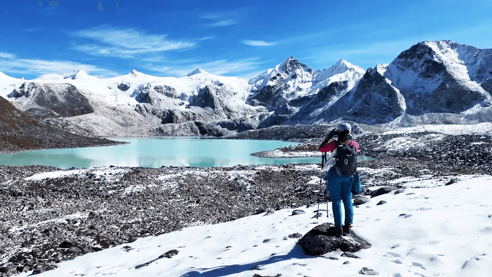
This is a day that will define the Snowman Trek for many who attempt it—crossing Jaze La at 5,150 meters, one of the highest passes on the entire route and one of the most demanding high-altitude crossings in all of Bhutan. Start before dawn; the crew will have breakfast ready at 4:30 AM. The ascent to Jaze La is long, steep, and at times technically challenging, involving sections of fixed rope or ice where the trail traverses exposed slopes. The thin air at this altitude makes every movement an act of will. Breathe deeply and slowly, step by step, and resist looking up too often—the summit seems perpetually far away. When you finally reach the prayer flags at Jaze La, the panorama is perhaps the greatest you will encounter on the entire trek: an unbroken circle of Himalayan giants stretching across 360 degrees of horizon. The wind at the pass can be fierce and bitterly cold; do not linger too long before beginning the descent. The trail drops steeply to the shores of Tsho Chena, a high-altitude lake at 4,960 meters that sits in a boulder-strewn basin. Camp on the flat ground beside the lake. The water is an impossible, opaque blue-green, and glacier ice floats on its surface. The temperature will drop to well below freezing tonight. Sleep fully clothed in all your layers.
Day 22: Tsho Chena to Jichu Dramo: Crossing Loju La (5,140m)
Another extreme day as the Snowman Trek maintains its relentless high-altitude character with the crossing of Loju La at 5,140 meters—barely ten meters lower than yesterday's Jaze La. By now your body has adapted as much as it will to these elevations, but there is no acclimatization that makes crossing above 5,000 meters routine. Every crossing demands the same respect, the same careful pacing, the same attentiveness to your body's signals. The trail from Tsho Chena climbs immediately, moving across a landscape of moraines, ice-polished slabs, and crevassed snowfields. The summit of Loju La offers views in every direction over a wilderness of peaks utterly devoid of human presence—no trail, no structure, no sign of anyone except the cairn of stacked stones and the wind-tattered offering of prayer flags. Descend from the pass across a series of undulating ridges and small alpine valleys to the camp at Jichu Dramo (5,050m). This is the highest campsite on the entire Snowman Trek, and the landscape surrounding it has a stark, alien quality—jagged peaks on every horizon, the air too thin for the lungs to feel satisfied even at rest. Eat everything the cook prepares. Tomorrow is the highest pass of all.
Day 23: Jichu Dramo to Chukarpo: The Roof of the World (5,320m)
Rinchen Zoe La, at 5,320 meters, is the highest point on the Snowman Trek and one of the highest trekking passes in all of Bhutan. Standing at its summit, you are higher than the base camp of many significant Himalayan peaks. The ascent from Jichu Dramo camp is immediate and unrelenting—there is no gentle warm-up today. The trail climbs straight toward the sky over ice, scree, and exposed rock. Crampons or microspikes are frequently necessary in September and October when the approach is iced. Every step above 5,000 meters feels slower, heavier, and more deliberate than it should. The mind narrows its focus: boot placement, breathing rhythm, the next five meters of trail. The summit of Rinchen Zoe La arrives eventually, as all summits do, and the sensation of standing there is unlike anything experienced lower down. On a clear day, peaks extending far into Tibet are visible to the north—a view of the high Himalaya that perhaps ten thousand people in all of human history have seen from this exact point. The descent from the pass is steep and requires extreme care, dropping into an entirely new valley system on the southern side of the main Himalayan divide. Reach Chukarpo camp (4,600m) in the late afternoon, utterly exhausted but deeply, wordlessly fulfilled. The hardest day of the Snowman Trek is behind you.
Day 24: Chukarpo to Tampetsho: Sacred Lake & Descent
The end of the Snowman Trek is now within reach, and today's walk carries with it a bittersweet quality that experienced trekkers often describe: the satisfaction of nearing completion combined with a genuine reluctance to let go of this extraordinary world. From Chukarpo, the trail descends further into the southern drainage before climbing once more to Tampetsho La (4,500m), the final major pass of the trek. The ascent is challenging but nowhere near as extreme as the passes of the past three days; at this stage, your body has been so thoroughly tested that Tampetsho La feels almost routine, a measure of how profoundly the mountain has changed you. From the pass, descend to camp beside the sacred Tampetsho Lake (4,300m), a stunning body of water in a natural rock basin. According to local tradition, this lake is the home of a powerful protective deity, and offerings of paper prayers, grain, and incense are commonly made at the water's edge by passing herders. The lake reflects the surrounding peaks in its still surface on calm evenings, creating a mirror-world of ice and sky. Sit at the edge of the water as the sun sets and let the beauty and the silence work their way into you. One more day remains. The mountains have one final gift to give.
Day 25: Descent to Sephu: The End of the Snowman
The final day of the Legendary Snowman Trek is one of the most emotionally complex days you will ever experience outdoors. The trail descends steeply and continuously from Tampetsho Lake, dropping through a rapidly changing sequence of environments—first the high alpine zone of boulders and bare soil, then the first scrub vegetation, then the increasingly lush forest of the lower valleys. With every hundred meters of altitude lost, the air thickens perceptibly, the temperature rises, and the world becomes softer, greener, and more habitable. The knee-pounding descent follows the Nikachu Chhu river downstream through a dramatic gorge before emerging abruptly at the road head at Sephu, where the sound of a vehicle engine—possibly the first you have heard in three-and-a-half weeks—is genuinely startling. Your vehicle is waiting. The support crew loads the equipment and animals are paid and farewelled with handshakes and, for those who have been together with the team through every pass, genuine emotion. The drive to Trongsa takes approximately 2–3 hours along the central highway, delivering you to a hotel where a hot shower, a soft bed, and a restaurant meal await. That evening, gathered around a table with your team, you will try to put into words what you have done and find that language is somewhat inadequate. The Snowman Trek is not just a walk; it is a transformation. Very few people complete it. You are now among them. Tashi Delek.
Ready to Book?
Contact us for a personalized quote.